Krakal Beach


Go to the next beach, about 6 kilometers from Kukup beach, we will find Krakal beach- a white sand beach stretch along 5 kilometers. Krakal beach the longest beach of the junction is located in Ngestirejo village, Tanjungsari district, about 3 km away in the east of Baron-Kukup-Sepanjang-Drini beach junction, has scratching white hill with blue slopes gently to the sea. The beauty of green lime-scratching hill with blue seawater offers a perfect harmony, which is very natural and ideal for sun bathing. Krakal beach mostly is a white sandy beach in Yogyakarta area. There's a development now because of its beautiful panorama of the southern sea. It should be careful here because it has big wave and the texture of the beach which are rocks meet the sands.
Among all the beaches that stretch along Java beaches, Krakal with its white sandy beach surrounded with mountainous rocky hills is the most beautiful one. Krakal is close to Kukup beach and Baron cove. This cove is in fact an estuary of an underground river that comes up exactly at the waterfront. It is interesting to observe the combination of the beach and the cove from the protruding rocky hills that flank the caves on both sides.


Prambanan Temple

This is the most famous and also the most magnificent of Central Java's temples or more precisely complex of temples. Situated about 15 kilometers from Yogyakarta, the top of the main shrine is visible from a great distance and rises high above the scattered ruins of the former temples. Prambanan is the masterpiece of Hindu culture of the tenth century. The slim building soaring up to 47 meters makes its beautiful architecture incomparable. Seventeen kilometers east of Yogyakarta, King Balitung Maha Sambu built the Prambanan temple in the middle of the ninth century. Its parapets are adorned with bas-reliefs depicting the famous Ramayana story. This magnificent Shivaite temple derives it name from the village where it is located.
Prambanan Temple is locally known as the Roro Jonggrang Temple, or the Temple of the "Slender Virgin", it is the biggest and most beautiful Hindu temple in Indonesia. The temple complex of Prambanan lies among green fields and villages. It has eight shrines, of which the three main ones are dedicated to Shiva, Vishnu and Brahma. The main temple of Shiva rises to a height of 130 feet and houses the magnificent statue of Shiva's consort, Durga. There are 224 temples in the complex; three of them, the main temples are Brahma Temple in the north, Vishnu Temple in the south, and the biggest among the three which lies between Brahma and Vishnu temples is Shiva Temple (47 meters high).
Two theatres have provided the temple. Enjoy sunrise behind the glory of Prambanan Temple. Visitors should be at the location - in the area of The Open Air Theater and archaeological park of the temple - before sunrise at about 5:00 o'clock in the morning. The First open-air theatre was built on the southern side of the temple in 1960 and the second was built on the western side of the temple in 1988. During full moon evenings in the month from May to October, the Ramayana ballet is performed right here. Perhaps one of the most majestic temples in the South-East Asia, Prambanan attracts many admirers each year from abroad.

Baron Beach

Baron beach lies in Kemandang Village, Tanjungsari district about 23 km in the South of Wonosari city. Baron beach is the first beach that would be found in the junction of Baron, Kukup, Sepanjang, Drini, Krakal and Sundak beaches area. It is a bay with big wave. Baron beach is popular as fish catching area. There is a mouth of Underground River that can be used for bathing after playing in the beach. The visitors can also enjoy various kinds of low prices seafood or fresh fish and Baron's special menu namely Kakap fish soup. There is limestone hill in this area. The visitors can reach that place by passing through a path. The way to go there is very interesting because it passes a place called Pegunungan Seribu (a thousand mountains).
Visitors could have a magnificent view of the beach; about 10 kilometers in the West of Baron beach there are Parang Racuk hill with its mountain slopes. It challenged the visitors to do some adventures. Every syuro month (the first month of Javanese calendar), the fisherman societies organized a Labuhan sea ceremony, to express their gratitude to the God for the abundant fish harvest and for the welfare in fishing.


Sundak Beach


Sundak is a beautiful beach located in Sidoharjo Village, Tepus District, Gunungkidul, Yogyakarta. According to the story which is told by the local residents, the name Sundak was taken and then used after in this location there was a fight between a dog and a hedgehog. The fight was initiated when a stray and hungry dog met a hedgehog in this beach. This hedgehog was chased down into a cave and then ended up eaten by this dog. The owner, who was looking for his dog saw his dog went out of the cave soaking wet with half of the hedgehog’s body. Curious, he checked into the cave and found the other half of this animal’s body and also a spring. After that fight, the owner of the dog called this beach as “Sundak.” Sundak is the combination of two words, “asu” which means dog, and “landak” which means hedgehog. Besides that, the spring that was found in that location was used as the water source for the local residents. Now a water pipe is installed here to flow the water into the settlements around there.
After accidentally named, this beach was getting famous and could attract visitors. It is not only because of the unique name, but also because of the beauty of this beach with its white sand and peaceful ambience. Now, this beach even has been visited by both local and foreign tourists. Because of that, Sundak Beach has been developed by the local government as the mainstay tourism object especially in the region of Gunungkidul. Although becoming mainstay tourism object for its region, this beach is still administered by the local residents, not the government.


Wediombo Beach

Wediombo Beach is a bay with white sand, which slopes gently to the sea, and it can be seen from the hill or even from the shore. Visitors can enjoy perfect sunset scenery from here. Wediombo beach is a natural beach with beautiful scenery. It lies in Jepitu village, Girisubo district, about 40 km in the south east of Wonosari city. It's a bay with white sand, which slopes gently to the sea, and it can be seen from the hill or even from the shore. The visitors can enjoy perfect sunset scenery from here and the fresh air is very good for the respiratory organs. For the visitors who have fishing hoby, Wediombo beach is a perfect choice. In a certain many of Panjo fish appear along the beach. It's a kind of fishing ceremony. In this ceremony, people use gawar, made from wawar tree's root as a net. The wawar tree's root is staked from Kedungdowok hill and pulled together into the sea by wediombo people.
In one area with Wediombo beach, there is Gremeng beach, Jungwok beach and kalong island (a small island inhibited by thousands of kalong). This island can be reach by tracing trough a pathway, about 1,5 km to the east.


Krakal Beach


Go to the next beach, about 6 kilometers from Kukup beach, we will find Krakal beach- a white sand beach stretch along 5 kilometers. Krakal beach the longest beach of the junction is located in Ngestirejo village, Tanjungsari district, about 3 km away in the east of Baron-Kukup-Sepanjang-Drini beach junction, has scratching white hill with blue slopes gently to the sea. The beauty of green lime-scratching hill with blue seawater offers a perfect harmony, which is very natural and ideal for sun bathing. Krakal beach mostly is a white sandy beach in Yogyakarta area. There's a development now because of its beautiful panorama of the southern sea. It should be careful here because it has big wave and the texture of the beach which are rocks meet the sands.
Among all the beaches that stretch along Java beaches, Krakal with its white sandy beach surrounded with mountainous rocky hills is the most beautiful one. Krakal is close to Kukup beach and Baron cove. This cove is in fact an estuary of an underground river that comes up exactly at the waterfront. It is interesting to observe the combination of the beach and the cove from the protruding rocky hills that flank the caves on both sides.


Parangtritis Beach

Parangtritis is located 27 km south of Yogyakarta and easily accessible by public transportation that operate up to 17:00pm as well as private vehicles. The afternoon before sunset is the best time to visit this most popular beach in Yogyakarta. But if you arrive sooner, it will not hurt for going up to Tebing Gembirawati (Gembirawati cliffs) behind this beach. From there, we can see the whole area of Parangtritis Beach, southern sea, up to the horizon.
Psst, YogYES will tell a secret. Not many people know that on the east side of this clifft, hidden temple ruins. Unlike the other temples located in a mountainous area, Gembirawati Temple is only a few hundred meters from the edge of Parangtritis Beach. To reach this temple, we can pass road uphill near the Hotel Queen of the South and then go down the path to the west for approximately 100 meters. Faintly roar of the ferocious waves of the southern sea could be heard from this temple.
Parangtritis Beach is very closely related to the legend of Ratu Kidul (Queen of South). Many Javanese people believe that Parangtritis Beach is the gate of Ratu Kidul’s magical kingdom who controls the southern sea. Hotel Queen of the South is a luxurious resort that is named according to this the legend. Unfortunately the resort is now rarely, whereas it used to have a view that could make us breathless.


Indrayanti Beach

The sun had not been high when  arrived at Indrayanti beach. Two sea snails moved slowly in a rocks niche, did not care that the wave was sweeping away. A bunch of teenagers was chatting while occasionally posing for picture taken. In the west appeared 3 people were running around chasing the waves, while others were relaxing in middle of the gazebo while enjoying the fresh young coconut directly served with fruit. Some inns conceptualized the back to nature stand proudly beneath the hill, while the stilt house and the huts that resemble honai (Papuan traditional house) were standing near the shore. A yellow jet ski was piled in the restaurant corner.
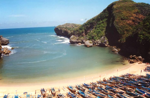
Located on the east coast of Sundak Beach, the beach that is lined by rocky cliff is one of the beaches that presents different views with other beaches in Gunung Kidul. Not only decorated with white sand, rocky hill, and the clear blue water as if calling for tourists to dive into it, Indrayanti Beach is also equipped with a row of restaurants and cafes and inns that will spoil tourists. A variety of menu ranging from seafood to fried rice can be ordered in a restaurant facing the beach. At night, gazebos at the beach will look pretty as lit by flickering lights. Enjoying dinner at the cafe accompanied by the sound of the wind and the waves will be an unforgettable romantic experience.
Mentioning the name of Indrayanti Beach ealier got a lot of controversy. Indrayanti is not the name of the beach, but the name of the cafe and restaurant owner. Since the name Indrayanti was displayed on the board of this beach cafe and restaurant, eventually people called this beach by the name of Indrayanti Beach. While the government named this beach as Pulang Syawal Beach. But the name of Indrayanti is more popular and more commonly known than Pulang Syawal. The involvement of private parties in the management of Indrayanti Beach apparently helped bring a positive impact. Unlike the other beaches that are rather dirty, the shoreline along Indrayanti Beach looks clean and free from rubbish. This is because the manager does not hesitate to impose a fine of Rp. 10,000 for each waste disposed by tourists carelessly. Therefore Indrayanti Beach becomes a comfortable place to visit.
After enjoying a plate of fried rice and coconut ice in the gazebo, It headed for the hills on the east side. Since there was no road, passing through bushes and shrubs while climbing rocks became an option. Arriving on the top of the hill, the views bounded by the Indian Ocean outspread. Some birds flew, carrying reeds to build a nest. The sound of the wave and the wind combined created a beautiful and soothing orchestra. Some beaches separated by hills looked lining up, gazebo and stage house looked small, whereas people looked like a little man. When dusk approached, this place would become a good spot to watch the sun returning to its resting place. Unfortunately had to hurry go home. Although not having seen a beautiful sunset, the charm of Indrayanti Beach has been imprinted in the heart.


History of Yogyakarta


The city of Yogyakarta is situated on Java Island, about 500 km southeast of Jakarta, the capital city of Indonesia.As the capital of Yogyakarta Special Region Province, the city has about 32.5 km2 area with a total population in 2004 of around 398,004 and population density of 12,246.28/km2 (National Socio Economic Survey, 2004). The city of Yogyakarta has a long and rich history, documented in Indonesian literature. It was founded in 1755, when the Sultanate of Mataram, which had been in existence since the 8th century, was divided by the Dutch East India Company (VOC) under the Treaty of Giyanti into two parts: the Sultanate of Ngayogyakarta Hadiningrat, with Yogyakarta as its capital, and Surakarta Hadiningrat, with Surakarta as its capital. During the Indonesian National Revolution (1945-1950) Yogyakarta played an important role in countering  the aggression of the Dutch after World War II . As one of the ancient cities in Indonesia, the  spatial development of Yogyakarta can be traced from its ancient origins to the most recent developments [2].Kraton, or the Sultan's palace, is the centre of the citizens’ activities in the social political, spiritual and economical spheres. It has public squares in the North and the South and a mosque in the West (known as Kauman great mosque).There is also a traditional market nearby (later known as Beringharjomarket). During its development, the location of the kraton, which is at the centre of Yogyakarta, drove the sprawl of the city in a unique and ordered pattern. The Kraton became the cultural centre and in many ways influenced the values and traditions of the society. 
References :
1.   National Socio Economic Survey, 2004. Number of Population by Sex,  Urban-Rural and    Regency/City in D.I.Yogyakarta,  Available at: http://www.pemda-diy.go.id/
2.  Adrisijanti, I. (2007, April 11-12). Kota Yogyakarta Sebagai Kawasan Pusaka Budaya: Potensi dan Permasalahannya (The City of Yogyakarta as Cultural Heritage Region,  Potencies and Problems. Paper presented in Historical Discussion "Kota dan Perubahan Sosial dalam Perspektif Sejarah" (Cities and Social Changes in Historical Perspectives) . Yogyakarta: Bala Pelestarian Sejarah dan Nilai Traditional Yogyakarta (Centre of Yogyakarta Historic Preservation and Traditional Values).
3.  Sholihah, AB. (2005). The Role of Informal Street Activities in The Context of Urban Cultural Entity Case Study :  Malioboro Street, Yogyakarta, Indonesia. Unpublished Master Thesis. Malaysia. UTM